Solo CT Anglers on the Housatonic, Sound, and Farmington Report the Same Failure Sequence When Trips Go Wrong. What Wading, Kayak, and Shore Communities Reveal About Float Plans, Tidal Windows, and the Exits Most Anglers Skip
Per USCG Recreational Boating Statistics, the majority of kayak drowning victims were not wearing a PFD — and most incidents occur in calm conditions, not storms. CT anglers who track DEEP incident summaries report a consistent pattern in freshwater as well: wading accidents disproportionately involve experienced anglers on water they know, not beginners on unfamiliar rivers. Familiarity erodes caution. Solo fishing concentrates every risk — no witness to your location, no one to call for help if a Housatonic current grabs you mid-wade, no backup when a Sound crossing goes wrong. The preparations that CT wading and kayak communities consistently treat as non-negotiable take minutes. But they have to happen before the launch.
The Float Plan Rule CT River Communities Treat as Non-Negotiable
Before any solo trip — a morning wade on the Farmington, a Sound kayak run, a hike into remote Pachaug watershed trout water — anglers across CT fishing communities cite the float plan as the preparation that changes outcomes. The mechanics: tell a reliable person the specific water and access point (not just 'the river'), your expected return time, and exactly what to do if they haven't heard from you by a stated hour. The final detail matters most. 'If I haven't texted you by 8 PM, call CT State Police at 860-685-8190 and tell them I was fishing at [specific access point].' That instruction cuts search-and-rescue response time from hours to minutes by giving responders starting coordinates rather than a county-wide search grid. Without one, a downed angler in the Pachaug drainage could trigger a search spanning hundreds of square miles. Anglers who fish remote CT DEEP-managed trout accesses — particularly wilderness parcels in the Northwest Corner and Pachaug State Forest — treat the float plan as standard practice because cell coverage disappears within a quarter mile of the trailhead on most of those properties.
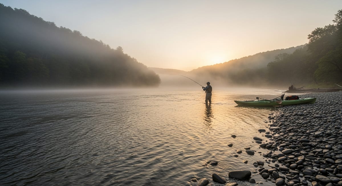
Housatonic and Farmington Wading Exits: The Step Most Solo Anglers Skip
Wading accidents account for a disproportionate share of freshwater fishing fatalities nationally, per USCG incident data. On CT rivers, the specific hazard is rapid flow increase from upstream precipitation — conditions can be calm at your location and dangerous within an hour if rain hit the upper watershed. Anglers who regularly wade the Housatonic through the Bulls Bridge gorge and the Farmington below Hogback Dam report the same discipline: plan the exit before the entry. Never wade a slot you cannot safely exit in every direction. If the return route across a fast seam isn't viable at current levels, it will not be viable after an hour of upstream rain. USGS Water Resources (waterdata.usgs.gov) provides real-time CT river gauges — the Farmington tailwater community treats checking levels before any wade trip as baseline, not advanced. Flow can shift faster than expected during spring runoff windows. If you go in: Roll onto your back, feet downstream to deflect rocks, and float toward calmer water. Panicked thrashing in current is a primary factor in wading drownings; a back float and controlled drift toward a slack eddy is how recoveries happen. CT wading communities consistently identify the folding wading staff (roughly $25–35) as the piece of gear that most changes solo river safety — it substantially improves stability on Housatonic cobble and rocky Farmington runs.
Long Island Sound Kayak Conditions: What CT Paddling Communities Report About Water Temperature and VHF
CT kayak anglers who fish Long Island Sound treat two practices as non-negotiable regardless of experience level: PFD on, always — and dress for the water, not the air. In April, Sound surface temperature typically runs 46–52°F. At those temperatures, cold shock and swimming failure can incapacitate an unprotected paddler within minutes of capsizing, per general cold water immersion research. CT kayak fishing communities — including anglers who launch from Hammonasset Beach State Park, East Haven, and Old Lyme access points — report wetsuits as standard for any spring Sound crossing where water is below 60°F, regardless of air temperature. Communication: A waterproof VHF radio on channel 16 is the baseline for saltwater kayaking, not an optional upgrade. A phone will not function reliably after submersion and may have no signal offshore. USCG Sector Long Island Sound monitors channel 16 continuously and responds to position calls. Visibility: A bright PFD (orange or yellow) combined with a shoulder-mounted light and whistle addresses the low-profile kayak problem — Sound boat traffic routinely misses kayaks in chop. CT kayak communities specifically flag the Niantic Bay approach and the Old Saybrook river mouth as areas with high commercial and recreational traffic that warrant shore-hugging routes rather than open-water crossings.
What Remote CT Watershed Anglers Actually Carry for Emergency Preparedness
Phone in a waterproof case: Primary emergency contact, but not a sole plan on remote DEEP parcels where cell service is absent. CT State Police dispatch: 860-685-8190. USCG Sector Long Island Sound: channel 16 (VHF) or 203-468-4401. Whistle: A Fox 40 pealess whistle clipped to the PFD shoulder strap is audible at significant distances, works after full submersion, and signals distress more effectively than shouting in wind. CT shore anglers report it as the most overlooked piece of gear relative to its cost (under $10). First aid basics: Hook removal tool, antiseptic, elastic bandage, and blister care covers the situations CT shore and river communities report most often — not dramatic injuries, but the small problems that turn a 3-hour trip into a 6-hour ordeal without support. Emergency blanket: A mylar space blanket addresses the hypothermia risk from an unexpected dunking — particularly relevant for early-season trout fishing in Northwest Corner rivers where air temps drop sharply after dusk. Food and water: Anglers who fish the Pachaug and Salmon River drainages note that a twisted ankle on an unmarked trail doubles a trip's duration with no resupply options nearby. Pack for the extended scenario, not the plan.
Tidal CT Rivers, Rocky Shore Surge, and Unmarked Watershed Trails: What Local Communities Report That Guidebooks Miss
Tidal lower rivers: The lower Connecticut, Thames, and Housatonic rivers are tidal and carry meaningful boat traffic. Kayak anglers launching from Old Lyme and Essex access points report planning around slack tide and staying near the bank as standard protocol — ignoring the tide window on the lower Connecticut creates a current-plus-traffic situation with limited margin. Rocky shore surge: Hammonasset, Rocky Neck, Harkness, and Bluff Point shore anglers consistently flag the set wave problem: conditions that look stable produce a surge without warning, and an angler who has turned their back to change tackle or handle a fish is caught off guard. CT shore communities report this as the most common near-miss situation on exposed rocky sections. Never turn your back to ocean surf on rocky ground. Remote watershed trails: Many CT wild trout accesses — particularly in Pachaug State Forest and Northwest Corner land trust parcels — require hiking unmarked trails where cell service is absent. Anglers who fish these drainages report downloading DEEP parcel maps and topography offline via CalTopo or OnX before leaving range, since in-app navigation fails without a pre-cached tile set. DEEP Wildlife Management Area boundary maps are available at ct.gov/deep but are not accessible without cell signal.
EVERY SATURDAY MORNING
Weekly fishing intelligence
Nationwide conditions, what's biting, and honest gear deals. One email, no noise.
No spam. Unsubscribe anytime.